Japan [93]


An economic giant, Japan does not command much territory. In fact Japan holds the world record GNP per square mile.

US Patent Holders [284]


This globe represents half of all patents in the US - those registered to
foreign holders. Countries with more than 1000 patents registered in
the US are indicated by name, with the point size of the representative
text scaled according to the square root of the total number of US
patents held. Japan accounts for roughly one third of foreign-held US
patents, followed by Germany, the UK, and France. Were the number
of domestically held US patents to be indicated according to this logic,
the entire surface of the globe would be covered.

Access To Drinking Water [255]


In the areas identified, the percentage of the population using improved drinking water sources is over 80%. Access is defined as within 15 minutes walking distance.

Freedom of the Press [250-2]


Freedom of the press across the globe is ranked in 4 tiers of brightness: Most Free, Free, Partly Free and Not Free, with the nations where press is afforded the most freedom of reportage shining brightest, and Not Free countries entirely blacked out. Number indicate the amounts of impediments - the lower the number the better.

Human Rights - Human Lights [230]


Every dot on this globe represents many thousands of people.
Just as humans - human rights are supposed to be universal as set forth in the Universal Declaration of Human Rights. However, in some countries they are seen as relative at best or only partially valid within the context of their cultures. (Bangcok Declaration)

Terrorism [225-3]


Darkened areas indicate presence of terrorist groups. Underlined groups are active in more than one country, underscoring their multinational and transnational character and ambition.

Population Bubble [43]

The question will not be what, but how to feed a population that will exceed 10 billion. Since 1985, due to agricultural engineering advances, the earth has yielded more food than we can possibly consume - yet geopolitical structures continue to leave millions of people dying of starvation.

Car Producing Countries [214]


Borders of all car-producing countries are highlighted even if no more than 30 (Mozambique) or 50 (Ethiopia) cars are made. Each dot represents a yearly production volume of 100.000 vehicles.

CO2 Spiral [30]


Between 1950 and 1986, annual carbon dioxide emissions have tripled. The principal source of these emissions is fossil fuel combustion, but natural gas flaring and cement production also contributes to the rising level. Carbon dioxide is the major cause of the Greenhouse Effect.

Ozone Hole [29-3]


A second permanent ozone hole was detected in the area of the North Pole in 1990, producing radical meteorological changes in parts of the Northern Hemisphere. In 1996, the World Meteorological Organization (UNO) measured the Southern Ozone Hole to be the size of the US and Canada combined. They are expected to increase in size until 2020.

TV Ownership [1]


Multiply the number of daily TV deaths by the number of people owning TV sets and subtract that number from the population. Most nations would disappear on a daily basis.

Refugee Currents [19]


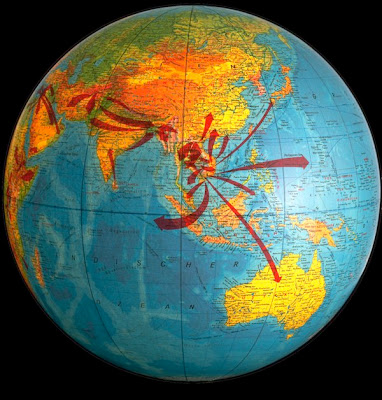
In 1990, UNHCR, the UN High Commissioner for Refugees, registered 20 million refugees, a number that increased to 27 million in 1995. While the overall number of refugees has decreased subsequently, the number of internally displaced people has radically increased. The widths of the arrows indicate the relative amounts of refugees (1970-1980).

Refugee (Republic) Network [154]


Refugees account for 1% of the world population. Most are parked in UN camps without awareness or knowledge of each other’s existence. Connecting these refugee camps would result in this refugee net. A Refugee Republic could be a trans-global, experimental, supra-territorial state for refugees to represent themselves worldwide. Implementing the idea of an open society and the ideals represented by the UN, it could become a model for other nations.

People Power [78]


The scale of regions reflects the size of population.

Rain Forest Leftovers [59-6]


Rain Forest Depletion: green indicates where rain forests still exist - red where it has perished.

Earth in 80 Languages [66]


The languages are not identified other than by their position (where there are most commonly spoken). The size of the words is proportional to the amount of speakers.

Population Distribution [63]


The world's 6 billion+ people are by no means spread out equally over the globe's territories — yet continental lines are easily identifiable since people seem to prefer coastal regions for settlements. More than half of the world's population lives on a relatively small territory spreading from northern India to China.